


Hiking in or out of the Malingsbo - Kloten Nature Reserve?
If you are thinking about hiking in or out of the Malingsbo - Kloten Nature Reserve, the rekommendation is to hike out of the nature reserve. Why? Your backpack will be way lighter when you are on your way back when you have consumed most of your food.
El sendero de Bergslagen - Bergslagsleden
El sendero de Bergslagen starts in the Malingsbo - Kloten Nature Reserve and winds south for 280 km along 17 stages.
El sendero de Bergslagen starts at the small village square in Kloten, between Wilderness Lodge's Bed & Breakfast and Nordic Discovery's Adventure Center.
You are able to download the hiking trail maps in your GPS or phone.

Bergslagsleden's trail extension to the north along Euro Trail 1
From Kloten, there continues a marked hiking trail through the Malingsbo - Kloten Nature Reserve to the north to the town, Smedjebacken. The distance is 39 km and Smedjebacken has direct train connections to Stockholm.
Accommodation along the hiking trail between Kloten and Smedjebacken: In the village Nyfors (12 km north of Kloten and 27 km south of Smedjebacken) it is possible to stay for the night at the River Loge. The River Loge is located along the hiking trail at the water front.

The hiking trail between Kloten (Wilderness Lodge) and Nyfors (River Lodge) follow the canoe trail and this stretch can be paddled in canoes and kayaks all the way to River Lodge, without extra cost then the rental price when you stay overnight at Wilderness Lodge or River Lodge. Information about the canoeing >>
Overview map over the Malingsbo - Kloten Nature Reserve >>
Train connections Smedjebacken-Stockholm
Hikers are highly recommended to do this hike with a detailed map. Detailed maps are for rent at Nordic Discovery's Adventure Center in Kloten.
You are able to download the following hiking trail maps in your GPS or phone.
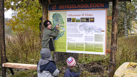
The starting point for the hiking trails
The small village square in Kloten is the connection point for the hiking trails. The square is located between Wilderness Lodge (Bed & Breakfast) and Nordic Discovery's Adventure Center. The Wilderness Lodge to the left and the Adventure Center to the right on the photo.

Road description to the starting point of the hiking trails >>
Safe and secure car parking at the starting point of the hiking trails
Car parking is limited in Kloten. The best place to park a car is at Nordic Discovery's guest parking on the meadow at the back side of Nordic Discovery's Adventure Center.

Car parking is free for clients. To become a client is easy. You are welcome to benefit the local economy by buying an ice cream, a soft drink or something else at Nordic Discovery´s Adventure Center. For long time parking the charge is 10 SEK/night.
Hiking maps
Hikers are highly recommended to do their hikes with a detailed map. Detailed maps are for sale and rent at Nordic Discovery's Adventure Center in Kloten. A map briefing about the hiking trails is included in the buying and the rent of the maps. The map rental is 25 SEK for 1 day, 50 SEK for 2 days, 75 SEK for 3 days and 100 SEK for 4 days and more. The price for new maps in water-resistant material is 250 - 300 SEK. Alternatively, you download the digital maps on this page in your GPS or phone.
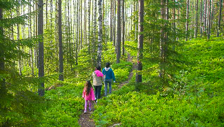
 Or you take a chance and set off without a map, but then you can get lost and run into the forest lady on the picture.
Overview map on the Malingsbo - Kloten Nature Reserve's hiking trails >> This map is not sufficient because all trails are not marked in the nature and there is a lack of good maintenance at same places (This is not applying to Bergslagsleden which is clearly marked and good maintained).
Winter hiking through the Malingsbo - Kloten Nature Reserve
You can do the hikes in the Malingsbo - Kloten Nature Reserve all around the year, but when the snow get too deep you need snow-shoes.

How do we know the local snow depth and if we need snow-shoes or not? You are welcome to ask Nordic Discovery about the amount of snow at the moment. Contacto con Nordic Discovery >>
Where can we find snow-shoes? Snow-shoes are for rent at Nordic Discovery´s Adventure Center. Information about the snow-shoes and snow-shoe rental >>
 The forest lady taking a rest and waiting for lost hikers to spellbind.